Lake Maumelle west of Little Rock offers a good supply of ducks, geese, gulls, terns, eagles, and other birds that like water. Like most lakes in Arkansas it is best in the fall and winter. The lake is a reservoir for central Arkansas and is managed by Central Arkansas Water who regulates access to it. There are however several points around the lake where good views can be found within easy walking distance of a state highway. Its important to note that while its primary purpose is to manage and protect the drinking water for 400,000 people, CAW is actively pursuing improvements in access to the lake for nature lovers of every variety.
All distances measured from intersection of Highway 10 and Chenal Parkway unless otherwise noted.
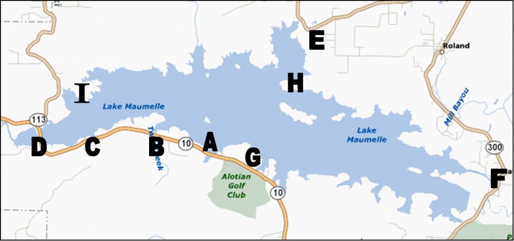
A. Loon Point, 7.8 miles west on Highway 10.
B. Old Marina and Frank Lyon Jr. Nursery Pond, 9.3 miles west on Highway 10.
C. Hundley Road Causeway 10.8 miles west on Highway 10.
D. Vista Point aka “Western Rest Area”, 11.9 miles west on Highway 10.
E. “North Shore Landing” 11.9 miles north on Highway 300 and Roland Cut-Off.
F. Lake Maumelle Spillway, 4.5 miles north on Highway 300 in town of Natural Steps.
G. Bufflehead Bay, 0.2 miles west of the Jolly Roger Marina.
H. Unnamed Peninsula in northeast region of lake.
I. Old Chimney Trail, 1.2 miles up Highway 113 from Highway 10.
The Loon Point area offers easy access to the lake shore where you can hike along the shore either east or west. It is good for ducks, loons, grebes, gulls, etc. Loon Point is on the west side of a bridge. From the parking area, you can walk westward along the bank and it will eventually come close to the road about a third mile from where you parked. On the east side of the bridge is a cut-out where you can park and walk on an old abandoned road and/or eastward along the bank.
The Old Marina and the Frank Lyon Jr. Fish Hatchery are next in line as you go west on Highway 10. The Old Marina is first and is behind a gated entrance with a multi-lane entrance. Until recently the gate had keep out signs on it but those are gone as of this writing. You have to walk in but its paved, easy, and short. You get a good view of the lake from here. The hatchery lies on the south side of the highway. It is a small sheltered lake that shows some activity although I would expect more. If I was waterfowl, I’d love it.
Between the Old Marina/Fish Hatchery and Vista Point is a causeway with water on both sides. Park on the side of the road just beyond the bridge. You can scope both sides of the road and the little bay on the south side is popular with gulls and ducks.
Vista Point or “the Western Rest Area” is just before the final Highway 10 bridge over the lake. From the rest area you have a clear view north through east, a spotting scope is recommended. You can walk along both sides of the bridge as well. Bridges usually imply there is water on both sides and this is no exception. On the western side of the bridge is a bay that usually looks pretty busy. The bad thing about that is the birds are usually on the far side. Fortunately, the Ouachita Trail runs along the lake shore here at least for a while and you can follow that to get closer to the reclusive birds. Like Loon Point, you’ll see loons, grebes, diving ducks, gulls, cormorants, and the occasional eagle.
North Shore Landing is an abandoned commercial landing near the north-most point of the lake. Now all that remains is a slowly decaying paved loop that is good for walking and waterfowl. To get there, take Highway 300 to Roland and then go straight for 2 blocks after 300 turns to the right at the start of “downtown” Roland and then turn left. This takes you to Roland Cut-Off Road. Take this for about 3.5 miles until it meets Highway 300 and then turn left back onto 300. Go 0.5 miles and 300 will turn sharply to the right and there will be a large dug up area in front of you to stop vehicular access. That is it, park where you can. The first part is the only marginally strenuous part of the area. Once you get past that, it is a paved trail that soon provides a good view of the lake. North Shore Landing is probably not as busy as some of the other points in this article but you do get varied habitats and frankly it is a nice pleasant walk. The Ouachita Trail cuts through this area.
The Lake Maumelle Spillway is easily accessible from Highway 300 in Natural Steps. Turn left onto Spillway Road just as 300 does a 90 degree turn to the right and follow it about two blocks until the road turns sharply to the right and starts to go uphill. There is a Central Arkansas Water sign on the left telling you all the stuff you can’t do there. The Ouachita Trail runs through here, in fact everything I cover here is along the OT. As you enter, look left to a wooded area. This is great for woodpeckers. Once done here, turn around and head the other way. It will open up giving plenty of habitat for sparrows, wrens, creepers, etc. The trail continues to the dam and then around into a pine forest and back to the lake again.
Bufflehead Bay is the first road to the right after the Jolly Roger Marina as you drive west. There is a gate that is usually open during birding hours with a parking area beyond with room for a few cars. The paved road continues for about 100 yards beyond the gate and then a natural trail runs beyond to give you a good view of the lake at the end.
Point H is a relatively remote peninsula that can be seen across the water from Loon Point. To get to it, look at the map above. Take the Roland Cut-off like you were going to North Shore Landing. On the map you see that the road travels straight due west until it bends 90 degrees to go north to the upper right of the H. At that corner, there is a gate and a dirt road. Park there and walk. After a quarter mile, you will meet another dirt road. Turn left on the new road and go about a half mile or a little more until you reach a relatively unmarked point and then you go “off road” and head west. Eventually you’ll be able to see shoreline. This is all undeveloped but you can walk around the shoreline and get good views of the lake. I recommend you study the area with Google Earth or similar tool and take a GPS unit to help you find the area.
The Old Chimney Trail is accessed from Highway 113 1.2 miles from its intersection with Highway 10. There is an old, now mostly hidden, road on the right at a slight bend to the left. Park and walk back toward the lake. Occasionally you’ll spot bits of asphalt so I’m justified in calling it a road or at least a driveway. The trail is becoming overgrown but is easily walked and goes about a mile back to the lake. The trail offers a good view of the bay about midway and from the endpoint you can see Vista Point, the Hundley Road Causeway, and its namesake the Old Chimney.

